Search This Blog in the above block
~ I dont blog about things to be liked. I blog about things that I like ~ ... so that one day, on my death bed, I will have said and done what I wanted to do, and die peacefully without regrets.
Live your life in such a way that when your feet hit the floor in the morning, Satan shudders & says..' Oh shit....She's awake'
Showing posts with label SANPARKS. Show all posts

Saturday, April 9, 2016

Hiking Half Collared King Fisher Trail in the Wilderness national park Garden Route

Wow, its been a while since I last blogged, but hey, starting an online magazine and having a precious little baby and life then happens, blogging kinda falls behind a bit.  I missed writing about our hikes, but we did not stop hiking, we just did not have the time to blog our hikes.

Anyway enough excuses, and while on holiday recently in the Garden route we stumbled upon a few hikes that I wish to share with you.  Before the hike and much of its details slip my mind, I will write about our experiences of these lovely routes and hope you get to experience them too!

For now, I will discuss the Half Collared King Fisher Trail.

Accommodation: Lake Pleasant Living Holiday Resort, Sedgefield.

Comes highly recommended, especially if you are a family.  They have all the amenities one can ask for and are in close proximity to all the major attractions.  The hotel staff were so incredibly accommodating and friendly, I will have no hesitation to want to go back there.

How to get there:  
Start by going to get your permit from the Ebb and Flow Camp at the SANPARKS Wilderness national park.  Below is a geographic map to show where it is in relation to Wilderness, a copy of my FitBit calculation of distance and time to complete the route is also shown.  Park your car inside the camp or there is a small parking area just next to the railway bridge outside the camping areas.


Take careful note of the map below and you will see the 2 sections that we did not cover while on this route: 
1. We did not opt to go the BOSDUIF trail, due to time constraints we did not explore this loop.
2. When doing the Bosduif, you also have the option to cross the river at THE STEPPING STONES.


Cost:
You need to pay a fee (R15 pp) at the Wilderness National park reception.  This is where they give you a map and all the important details.  It's free if you have a Wild Card of course.
Distance:
4 km one way (8km return). Give yourself 4 hours, but nothing less, unless you plan to run it.
Difficulty:
Easy but not for an old dog.  In fact this is not a route where dogs are allowed, the boardwalks can cut their feet in the wet slippery conditions.  Its practically flat the whole way, with a very super fancy board walk to guide you in your adventure through this beautiful forest.


Exit the Ebb and Flow South Rest Camp, and turn left to walk about 100m over the single lane railway bridge over the Touw River.

Opposite the Wilderness water purification plant, you will see a sign to mark the start of this hiking route.


No need to worry too much about a map or a guide, as this route is as clear as you can get. It is however nice to have a map, because the you can always have a good understanding of your location when you get to places where the road forks, the pontoon or the waterfall.


In the beginning you walk below a shaded canopy, and a few board walks to take you over the tricky parts of the mountain.

Scenic views are around every corner.  In this photo you can still see the Ebb and Flow North Camp site on the opposite side of the river.

In the image above you can clearly see how the river meanders into the background, clearly marking the path ahead of you.


You are also able to hire a kayak (from the reception) and paddle for half of the distance to a set point in the river.  We would loved to have done this too, but we started so late (3pm!), time was not on our side.  The kayak adventure looked so stunning. Would love to come back and do this part of it just for fun.


As we walked we found many well market picnic spots along the river.


This route hugs the Touw river all the way to a waterfall.


When to go:
Most of this walk is done in the shade and on a wooden board walk.  This should give you enough information to decide whether you would like to do it in summer or winter, on a dry or rainy day. "Slippery when wet" comes to mind here ;)


Halfway to our destination we had to cross the lovely Touw river by means of a fun pontoon.  Each to their own here.
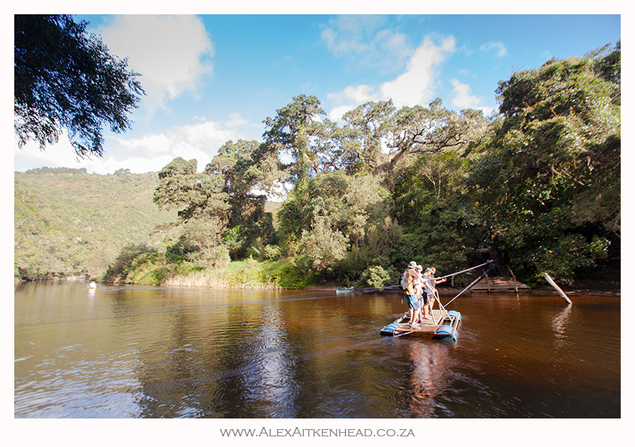


A selfie was the order of the day while crossing the river on the pontoon !


A short distance after we crossed the pontoon, we found the Kayak-stop.  This is where the rowers parked their kayaks to continue their journey on foot to the waterfall another 2km further.


The tranquility of the river was the perfect spot for us to take a short break and enjoy the moment.  Our 2 year old son loved the cool water and 'rocks for Africa' to throw...


This well maintained board walk was an absolute pleasure, never been so spoilt for such a long distance on a hike before!


Eventually after 2 hours and 4km later, we reached the waterfall.  


From here we turned around and raced back, daylight time was not on our side as neither of us brought a Petzl with us and both of us ran out of phone battery.  Rather silly, but we did not expect this route to be as nice, and so long.  Key here is to always come prepared I guess.


Feel free to ask questions in the box below, I will be happy to help if I can.  Thanks,

As for the King Fishers... I did not hear or see any???

PS:  all these pics were happily shot from my Sony Xperia waterproof phone that I love, but there are a few beauties squeezed in that my hubby took with his brick ;)

Happy Hiking!

Wednesday, September 7, 2011

Cape Point Free Guided Walks

Sanparks: Free Guided Walks at Cape Point

There are enthusiastic volunteers who are now offering free guided walks at Cape Point.
Please note:
  • Meeting point for all hikes is just inside the main gate on the 2nd Sunday of each month.
  • Walkers must wear strong boots and have hat, sun block, rain gear, water and a snack.
  • You can purchase an activity card (obtainable at Boulders or Westlake) or pay admission/ conservation fee at the gate.
  • There is no payment for the walk. ***note different start times***
  • Enquiries: John 021 782 2379 Ian 021 782 8552
Date Route Approx Distance Starting Time Hours Leader
May 8 Olifantsbos Road to Sirkelsvlei and Return 5km 09:00 3 Des: (021) 782 1375
June 12 Sirkelsvlei Circuit (from Olifantsbos) 6km
10:00 3.5 Ron: (021) 789 1918
July 10

Buffelsfontein Visitors Centre to Antonies Gat and Return via Beach 8km 10:00 4 John: (021) 782 2379
Aug 14 Hoek van Bobejejaan Circular Route 5km 10:00 3 Ian: (021) 782 8552
Sept 11
Gifkommetjie to Good Hope 8km 09:00 4 John: (021) 782 2379
Oct 9

Shipwreck Trail (starting from Gifkommetjie) 6km 09.00 3 Ian: (021) 782 8552
Nov 13

Kanonkop Trail (From Visitors Centre) 6km 08.00 3.5 Ian: (021) 782 8552
Dec 11
Mystery Hike 8km 08.00 4.5 John: (021) 782 2379

Wednesday, July 6, 2011

Wildcards have arrived finally

Wildcards arrived in the post, loaded with errors.

Well, I am very glad that our Wildcard finally arrived, but it took some serious begging, pleading and moaning to the folks at SANParks who are in charge of this department.

The kind lady who mainly runs the Wildcard page on Facebook, offered to help us out.  It was through her that she found out almost all our details (phone, address, emails and spelling of surname) had some sort of fault in it.  I have a copy of my application that I gave in (as I could only do... I took a photo of the application form before I gave it in at the office in Westlake, but will not load for privacy reasons), and I can remember clear as bells, that I wrote very neatly on the application - for us to have avoid this very experience.

Needless to say, we now have the Wildcard and wish to make you aware that your Wildcard might have suffered the same fate and its worth your while to go and look online or call them directly to confirm the delay.

Happy Wildcard hunting !

.

Monday, May 23, 2011

Cape Point Free Guided Walks

Sanparks: Free Guided Walks at Cape Point

There are enthusiastic volunteers who are now offering free guided walks at Cape Point.
Please note:
  • Meeting point for all hikes is just inside the main gate on the 2nd Sunday of each month.
  • Walkers must wear strong boots and have hat, sun block, rain gear, water and a snack.
  • You can purchase an activity card (obtainable at Boulders or Westlake) or pay admission/ conservation fee at the gate.
  • There is no payment for the walk. ***note different start times***
  • Enquiries: John 021 782 2379 Ian 021 782 8552
Date Route Approx Distance Starting Time Hours Leader
May 8 Olifantsbos Road to Sirkelsvlei and Return 5km 09:00 3 Des: (021) 782 1375
June 12 Sirkelsvlei Circuit (from Olifantsbos) 6km
10:00 3.5 Ron: (021) 789 1918
July 10

Buffelsfontein Visitors Centre to Antonies Gat and Return via Beach 8km 10:00 4 John: (021) 782 2379
Aug 14
Hoek van Bobejejaan Circular Route 5km 10:00 3 Ian: (021) 782 8552
Sept 11
Gifkommetjie to Good Hope 8km 09:00 4 John: (021) 782 2379
Oct 9

Shipwreck Trail (starting from Gifkommetjie) 6km 09.00 3 Ian: (021) 782 8552
Nov 13

Kanonkop Trail (From Visitors Centre) 6km 08.00 3.5 Ian: (021) 782 8552
Dec 11
Mystery Hike 8km 08.00 4.5 John: (021) 782 2379

Sunday, March 6, 2011

Footprints Revealed - Video of our Road-trip to the Richtersveld, Kgalagadi, Augrabies and Namaqua

This post is not really about hiking, but I thought I'd share this article with you anyway, as we did to a short 3 hour walk in the Kgalagadi during our trip.  Hiking in this area during December is either prohibited or not advisable due to the extreme heat.  Hope you like watching our videos :)

We visited the Richtersveld and Kgalagadi in Dec 2010 and I did a video of our trip. 

Anyone interested in seeing what it looks like here, or have been here to be reminded of your trip to these locations, might be interested to see the videos of these 2 arid parks.

The reason why I recorded it was for the viewer to see what the environment looks like, the type of roads to expect if you go here and the type of accommodation available if u planning a trip to these destinations. I lost the footage of day 1, so it was replaced with photographs, but the rest of the road-trip is video and photographs combined.


Under each link is a short description of the content.  Ideally I would have put the whole video on the forum post, but Im not sure if it is possible, so here are the links:

Day 1 & 2 going to the Richtersveld - Dec 2010
The start of a 11 day road-trip :)  Leaving Cape Town on the 21st of December 2010, heading for a small village in the Richtersveld called Kuboes which was recently also declared a "World Heritage Site"  This video series (Days1 - 10) shows you what to expect if you choose to also visit these places.  We hope you will find it informative, as we had fun making this video especially for this reason.  Thanks for watching !!!

Day 3 Richtersveld - Dec 2010
Day 3, we leave the Richtersberg campsite, and travel to Kokerboomkloof, Helshoogte and Akkedis pass. Along the way we see some more hard core 4x4 types passing us with caravans in tow (respect to them!) as this is a extremely harsh and rugged environment for any visitor traveling through this arid park. At the end is a quick look at the accommodation in Sendelingsdrif on the banks of the Orange River. 

NOTE: This footage was shot about 2 weeks prior to the river level rising by 8-9 meters (from about the 2nd week in January 2011) and most of it got damaged or washed away.

Day 4 am Richtersveld - Dec 2010
From our overnight spot in Sendelingsdrif in the Richtersveld, we cross the Orange River by the pontoon, and head into Namibia to drive along the road next to the Orange River.

Day 4 pm Richtersveld / Namibia side - Dec 2010
Crossing over the Fish river at the point where it flows into the Orange River, passing Aussenkeihr, Noordoewer and heading towards Bushwacked to go river rafting.


Day 5 Fish River Canyon - Dec 2010
Leaving from our river rafting venue (Bushwacked) by the Orange River, we head back into Namibia to the Fish River Canyon, via a quick stop at the /Ai-/Ais, to overnight at The Canon Roadhouse.


Day 6 Road to Kgalagadi Dec 2010
Do you want to know what the roads look like driving there?  Then this explains it a little. You see the entrance to the reserve and some animals and a small section on the Urikaruus Camp.  I think that this camp is built from materials to make for a very hot spot in summer and freezing in winter. I did not like staying here one bit. We were here in the heat of summer and from experience I can just imagine that this place must be as cold in winter as it was hot in summer. The old mining style buildings just does not work for me when it comes to shelter / temperature control.

Day 7 Urikaruus to Nossob - Kgalagadi Dec 2010

Wow, this day was jam-packed with a variety of wild animals... almost every animal on this road trip was an experience to remember. Animals in this video are bat-ear fox, black-backed jackal, black mane lion, cheetah, ground squirrel, cheetah chase, secretary bird coming in for a graceful landing and a typical sandy whirlwind, baby springbok fawn, baby barking gecko.

Day 8 The unfenced Polentswa camp - Kgalagadi Dec 2010
A drive from Nossob Camp to our next stop for the night, the Polentswa unfenced camp. 

Day 8 midday Polentswa Raptors - Kgalagadi Dec 2010

Who would have thought they let them out the cage at midday?!  Wow, what a spectacular sighting this was for us... about 20 raptors frolicking in and around the Polentswa watering hole at the same time.  Our best sighting of the trip! spent hours here and loved every second of it.

Day 9 early am Polentswa and the Brown Hyaena - Kgalagadi Dec 2010
We went to the watering hole at Polentswa to see if we can find something, and this beautiful Brown Hyaena came to drink some water.  He seemed very shy too.

Day 9 late morning Polentswa to Nossob - Kgalagadi Dec 2010
After a quick stop at the Polentswa watering hole, we headed back to Nossob Camp.  We found a male lion roaring away in the heat of the morning... the same culprit who kept us awake the night before.

Day 9 pm Nossob to Kalahari Tented Camp - Kgalagadi Dec 2010

We found a lion resting in the Dikbaardskolk picnic spot and a Martial Eagle drinking rainwater in the road.


Day 10 pm Augrabies Dec 2010
We left the Kgalagadi Transfrontier Park around lunchtime and headed for Augrabies which we were told is in flood.  Little did we know, that about 10 days later, this waterfall increased about 5 times to what you see in this video and washed the viewpoints away...

NOTE: This footage was shot about 2 weeks prior to the river level rising by 8-9 meters (from about the 2nd week in January 2011) and most of it got damaged or washed away.


In conclusion, we drove 4300km over 11 days and stayed in a different spot each night. It was far and hot.  95% of the cars that we saw were Toyota Raiders.  Our Toyota Raider was such a pleasure to be in and we understood why: the car was very comfortable to drive and made for these type of environments.  From now on, we will try to stay in one accommodation for at least 2 nights or more.   Our next park to visit is Tankwa then Kruger and probably back to the Kgalagadi...

Monday, January 10, 2011

Kgalagadi Richtersveld Augrabies Namaqualand

We spent about 6 months planning our roadtrip to the Northern Cape.  It went by in a flash.  We went to look for a place called no-where and found nothing.  We also went to a place called the Kgalagadi. If I had to describe it, I would say it was an experience of a life time.

They say if you go to the Kgalagadi, you will always want to go back.  Well, for us it was like that for sure, but we also want to go back, because even though I grew up next to Kruger and spent most of my life in it, we felt like city slickers stepping into no-mans land.  Booted and geared to the tipping point of perfection (or not!)  On the other hand, that city feeling - TIME - and not having enough of it, never left our side.  "we need more time!" was key to our subconscious most of the 11 days.  4100km later, we arrived back home, already planning for our next adventure.

We will be going back some time for sure, this time armed with a tripod mounted to the car - promise.  The images are being edited and the story is being written, and as soon as I have enough TIME - now that Im back at work - I will load this mind blowing experience on here to share with you our whirlwind tour through the Northern Cape.

Even though our video clips will not be movie-like quality, we had so much fun recording this trip to the Richtersveld, Kgalagadi, Augrabies and Namaqualand.  In the mean time, if I were you, get your anti-nausea tablets ready, because my video clips will soon be uploaded and hope you will enjoy the ride with us.

I know, holidays should be exactly that.  Lessons learnt: spend more time in 1 location and since we are so into our filming and photography, marry the tripod!

Monday, November 22, 2010

Wildcard Renewal process sucks

So far this has been my experience in getting our WildCard updated:

1 Nov:
Get email notification that Infinity no longer manages Wild Card. they said to pls go to SANPARKS website and update your card so that the new management have what they need to have.

  • we go there to update the information.  We get linked to www.wildcard.co.za and then we have to find the form...
19 Nov:
get sms from INFINITY to say the following:
"WILD Cardholder: Your WILD Card, 1234xxxxx, is expiring on 21/12/2010. GO WILD, renew your WILD Card by calling 0861234002 or visiting www.wildcard.co.za"

  • since we have done the website thing, we called the given number.
  • we get told to go to the nearest WildCard (Sanparks) office... Canal Walk Entrance 2.
  • at the office in Canal Walk we get given and told to fill in this form and fax it to 021 701 8773 (Done)

after completing the above form, I venture off to phone SANPARKS on 0861 469 453, the phone rang and then I was put on hold for 4 minutes, and then got cut off.

again, I decided to call 0861234002 again to find out something else, again they refer me to Sanparks.

my point being:
all this backwards and forwards commotion to get this card updated so that we can go on holiday with a valid card... getting directed from pillar to post.

  1. After updating our info on the SANPARKS website, they now tell us its not valid we have to do it again.  we do it again... for just in case.
  2. Calling the number on the Wildcard sms, only to be told we must actually call another number...
  3. Call the other number, to be put on hold for 4 minutes and then get cut off...
  4. going to Canal Walk to be told its not there its somewhere else...
  5. have been given the above form to fax off into cyberspace and hoping something will be done about it.
why all the missioning? why not send out 1 sms to refer us to SOMEONE SOMEWHERE that can help us to get it done first time. 
    I just dont know how companies actually survive.  grrr

    Monday, September 13, 2010

    Free access to South African National Parks 13 - 17 Sept 2010

    Media Release: Free access to National Parks starts this week

    From Monday, 13 September until Friday, 17 September, the country’s body charged with the management of national parks, South African National Parks (SANParks) will allow locals with valid identity documents an opportunity to spend a day at a national park of their choice free of charge.

    The week-long campaign giving free access to the national parks will be applicable to all the national parks managed by SANParks, with the exception of Boulders in Table Mountain National Park, Tankwa and Namaqua National Parks.

    According to SANParks General Manager: Media Relations, Reynold Thakhuli, the objective of the week is to cultivate a culture of pride in all South Africans in their relationship with the country’s natural, cultural and historical heritage, under the established theme “Know Your National Parks”.

    The idea of a national parks focus week was conceived in 2006, after a realisation that a vast majority of South Africans were not accessing the national parks. “SANParks then embarked upon this campaign to encourage all South Africans, especially those from the communities around the parks, to share in what SANParks envisions to be “the pride and joy of all South Africans and the world”.

    The feature element of this campaign is the free access granted to all South African day visitors carrying their official Identity Documents. Young persons under the age of 16 will be allowed free access without the requirement of proof of identity. It must be noted that the free access to the parks will not include any commercial activities in the park such as guided safaris in vehicles or guided walks, etc.

    “Environmental education and protection is the responsibility of everyone, not just a privileged few. If we are to create a sense of ownership of the natural heritage of South Africa in all South Africans, then all South Africans must be able to have access to such,” said Thakhuli.

    “We especially want our young people to take advantage of this opportunity because this heritage will be under their protection in the near future,” added Thakhuli.

    “The annual SA National Parks Week has been made possible with support from First National Bank since inception. “In recent years, awareness of environmental issues and the impact we have on our environment has increased greatly. At FNB we recognise the immediate and potential threats posed by global warming and other environmental issues, and have taken steps to minimise our impact on our surroundings, said FNB Public Sector Banking CEO National Government,” Yvonne Zwane.

    “FNB has embarked on environmentally friendly initiatives such as: energy saving that reduces the load on the Eskom grid, water conservation processes, paper saving initiatives and encouraging the use of recycled paper. This precipitates environmental impact reduction for a sustainable future through energy efficiency, water efficiency, waste re-cycling and indigenous gardens. Furthermore FNB has completed initiatives such as the development of the environmentally friendly Fairlands Building moving South Africa a step closer towards an environmentally friendly society,” concluded Zwane.

    SANParks encourages all South Africans and especially educators and school groups to diarise these dates and plan a visit to a national park nearby.

    For more information and activity list visit: http://www.sanparks.org/events/parks_week/2006/

    Visit us on: www.sanparks.org
    Joining our discussion forum: http://www.sanparks.org/forums/
    Follow us on Twitter: http://twitter.com/SANParks
    Become a fan on Facebook: http://www.facebook.com/pages/South-African-National-Parks/20031840634
    Issued by:
    SANParks Corporate Communications

    Media Enquiries:
    Reynold “Rey” Thakhuli – GM: PR, Media & Stakeholder Relations, tel: (012) 426 5203, cell: 073 373 4999, e-mail: reyt@sanparks.org

    Tuesday, June 22, 2010

    Accommodation for the Fish River Canyon

    We have booked our roadtrip to the Richtersveld and Kgalagadi , but I have a problem finding accommodation for the Fish river canyon.

    All we want is a reasonably priced chalet to put our heads down en route from the Richtersveld to Kgalagadi. We are even happy to camp, but would like the chalet option - since we are spending only 1 night in a place.

    The reason for my asking this too is that when we went to Addo, we had no idea there were SO MANY Bed and Breakfast spots just outside the park... as we had to plan our whole holiday around the few days they had spare for us inside the park... had we only known.

    any suggestions (other than the Canon spots and the Ais-Ais) will be great, thank you.

    Sunday, June 6, 2010

    Hiking Smuts Track on Table Mountain

    Hiking Smuts Track was not a another walk in the park.  Again, another breathtaking walk - famously known to have been the route of General Jan Smuts which he walked up to the age of his mid eighties.


    I had my heart rate monitor on, and burnt 1680 calories from start to end.  Had we not done the cable way down, Im sure I could have added another 400 calories to this figure.

    The route starts at the foot of the mountain by Kirstenbosch Botanical Garden.  It cost us R35 each to get through the gates and onto the route, which is via Skeleton Gorge.

    Follow the Skeleton Gorge signs inside the Botanical gardens.

    Kirstenbosch Botanical gardens is also a very popular venue for Concerts in the Park.

    The path going up varies between wooden foot steps and well placed rocks.

    This route is a difficult and potentially dangerous climb, particularly in wet weather.


    A good 30 minute walk from the TOP Entrance gate in Kirstenbosch, will take you to cross over the Contour Path and a small sign indicating the start of Smuts Track (there is no confusion as to which way it is, but only up)

    The path zig-zags its way up the steep stone steps into the gorge. During winter this is the main flow down for the Liesbeeck river. I particularly love this section of this route the most. Its not often that one can see so much green moss covering the rocks in such a condensed area.


    About two thirds of the way up Skelleton gorge, we reached a few wooden ladders (and gladly no chains as the sign indicates).  These wooden ladders are a real welcome!  Usually by now we've had our second break, but today was one of my stronger days for climbing and we went up in one go all the way to the top.

    Looking at these pictures, Im very sad to say that my new Blackberry 9700 Bold takes very poor pictures compared to my Nokia N82.  Dont get me wrong, I just love the Blackberry for what it has to offer for business etc, but for taking photo's it gets a thumbs down. Had I not dropped my Nokia so many times (on my hikes!) and it was still working, I would have used it hands down as my main source for taking my pictures.

    Once we emmerged from the Gorge and its dense forest below, the view of False Bay and the Helderberg is clearly seen.  During a cold winters day, the rays of the sun is also a warm welcome.

    From here, we walked another 20min up the steep incline before we reached our next crossroad.

    At the first crossroad once we reached the top, we turned right to follow the path hugging the side of the mountain overlooking Kirstenbosch and surrounds.

    The good news is we reached to top of Skeleton Gorge, the bad news was... the 'mountain' ahead of us.

    Its very disheartening if you think you have reached the top, when you see another monster hill in front of you.

    Our GPS indicated that we were on about 800m from here, and we had another 280m to go before we reached our peak... MacClears Beacon.

    The climb to the top of the beacon was actually a beautiful walk and fairly easy to walk in about 1 hour from the top of Skeleton Gorge.


    At the top of the fabulous walk we were again blessed with a near 360 degree view of the Cape!  This is for sure a must do walk if you have not done it.


    MacClears beacon marks the highest point on Table Mountain of 1080m.  We started walking at an altitude of 50m, so a 1km climb over about 4.5km is not too bad for one to consider it a good walk for the day.

    We found a comfy spot on the rocks at MacClears Beacon to have our halfway mark lunch break.  Looking down onto our route of last week - Devils Peak.  Im still keen to find a way from Devils Peak to MacClears... not sure if there is one?  Have seen a few faint paths on Google Earth, but Im going to have to set out on a mission to find this one.

    Due to our respect for this majestic mountain, we are very careful to not just go wandering off onto some route into the unknown...


    After a short break, we ventured on - heading directly for the cable way.  This path follows a almost flat path all along the face of Table Mountain.  I just love it here, and would recommend it to anyone to come and see the views this fairly easy and flat section has to offer.

    The path literally hugs the cliff face for us to enjoy looking down onto Lions Head and the city of Cape Town almost all the way back to the Cable Station.

    Thissection is us looking at Platteklip Gorge from an angle we are not too familiar with.  Platteklip Gorge is the easier route to walk up to the top of Table Mountain if you do not wish to take the cable way.  Be sure to remember that Plattes (as known by the locals) has no mercy for the unfit either. 

    The Upper Cable Station is very well equipped - the walkways are also made for easy access for disabled persons - and there is a rather pricey restaurant / coffee shop at the top.
     Ha ha, this is Alex - DONE!!!  I dont often find him chillaxing like this after a walk...  blaming it on a weak stomach - I told him to ease off on the italian salami he had the day before :)

    We remembered to take the Wild Cards, which eased off on the price tag of taking the Cable Car down.

    Normal price is about R85pp one way, but it cost us R68pp as South African Citizens we had the Wild Cards which helped us get it at a more discounted rate.

    You can also buy tickets online if you dont feel like standing in the queue. Note: This queue for the cable way coming up is often over an hour long.

    This is a snap that I captured as the cable car started moving down - with the lower Cable Station in sight.


    Here is the view from the cable car, looking at the point of mountain we had just come from... I just love staring at the mountain after a walk... trying to see if I can recognise our path we had just done.

    Another favourite thing of mine to do, is to draw our route of the day off Google Earth map.

    Before I got the Garmin eTrex Legend, I used to do this type of picture manually.  Now the GPS does it for me automatically.  Love it!


    Costs of route:
    R35pp entrance fee to Kirstenbosch Botanical Gardens
    R68pp down the cable way with a Wild Card.

    Distance: 8.5km
    Altitude: start 50m to 1080m at MacClears Beacon
    Calories: 1680
    Time: 4 hours


    What a walk!  We did this walk just over a year ago, but forgot to take pictures (it was raining and we had a white-out on the day - loved that toooooo!), but at that time we were focusing on staying on the track. Great walk, great workout and good all round fun as part of living the life that our environment has to offer us.

    New to reading blogs?

    I have heard so many people saying they are new to reading blogs. Here is the 'low down' of what you need to do:

    1. The blog is written in date order. Latest posts are at the top and older posts below them. Older posts have a link to them - find the link if you scroll right to the bottom of this screen - see Older Posts.
    2. Click on the post header if you wish to make comments below the articles. Comments are most welcome :)
    3. I blog our hikes to help other people find nice hiking routes, but also because we love taking pictures on our hikes.
    4. On the right column are images of some of the hikes we have done so far. Click on the images to read about those hikes.
    5. Subscribe to my newsletter if you wish to get updates of new posts. I will not inundate you with mails - promise.

    Thanks for reading my blog and hope you enjoy the read.

    There is an old saying...

    The more you learn, the more you realize how little you know.