Search This Blog in the above block
~ I dont blog about things to be liked. I blog about things that I like ~ ... so that one day, on my death bed, I will have said and done what I wanted to do, and die peacefully without regrets.
Live your life in such a way that when your feet hit the floor in the morning, Satan shudders & says..' Oh shit....She's awake'
Showing posts with label Garden Route. Show all posts

Saturday, April 9, 2016

Hiking Half Collared King Fisher Trail in the Wilderness national park Garden Route

Wow, its been a while since I last blogged, but hey, starting an online magazine and having a precious little baby and life then happens, blogging kinda falls behind a bit.  I missed writing about our hikes, but we did not stop hiking, we just did not have the time to blog our hikes.

Anyway enough excuses, and while on holiday recently in the Garden route we stumbled upon a few hikes that I wish to share with you.  Before the hike and much of its details slip my mind, I will write about our experiences of these lovely routes and hope you get to experience them too!

For now, I will discuss the Half Collared King Fisher Trail.

Accommodation: Lake Pleasant Living Holiday Resort, Sedgefield.

Comes highly recommended, especially if you are a family.  They have all the amenities one can ask for and are in close proximity to all the major attractions.  The hotel staff were so incredibly accommodating and friendly, I will have no hesitation to want to go back there.

How to get there:  
Start by going to get your permit from the Ebb and Flow Camp at the SANPARKS Wilderness national park.  Below is a geographic map to show where it is in relation to Wilderness, a copy of my FitBit calculation of distance and time to complete the route is also shown.  Park your car inside the camp or there is a small parking area just next to the railway bridge outside the camping areas.


Take careful note of the map below and you will see the 2 sections that we did not cover while on this route: 
1. We did not opt to go the BOSDUIF trail, due to time constraints we did not explore this loop.
2. When doing the Bosduif, you also have the option to cross the river at THE STEPPING STONES.


Cost:
You need to pay a fee (R15 pp) at the Wilderness National park reception.  This is where they give you a map and all the important details.  It's free if you have a Wild Card of course.
Distance:
4 km one way (8km return). Give yourself 4 hours, but nothing less, unless you plan to run it.
Difficulty:
Easy but not for an old dog.  In fact this is not a route where dogs are allowed, the boardwalks can cut their feet in the wet slippery conditions.  Its practically flat the whole way, with a very super fancy board walk to guide you in your adventure through this beautiful forest.


Exit the Ebb and Flow South Rest Camp, and turn left to walk about 100m over the single lane railway bridge over the Touw River.

Opposite the Wilderness water purification plant, you will see a sign to mark the start of this hiking route.


No need to worry too much about a map or a guide, as this route is as clear as you can get. It is however nice to have a map, because the you can always have a good understanding of your location when you get to places where the road forks, the pontoon or the waterfall.


In the beginning you walk below a shaded canopy, and a few board walks to take you over the tricky parts of the mountain.

Scenic views are around every corner.  In this photo you can still see the Ebb and Flow North Camp site on the opposite side of the river.

In the image above you can clearly see how the river meanders into the background, clearly marking the path ahead of you.


You are also able to hire a kayak (from the reception) and paddle for half of the distance to a set point in the river.  We would loved to have done this too, but we started so late (3pm!), time was not on our side.  The kayak adventure looked so stunning. Would love to come back and do this part of it just for fun.


As we walked we found many well market picnic spots along the river.


This route hugs the Touw river all the way to a waterfall.


When to go:
Most of this walk is done in the shade and on a wooden board walk.  This should give you enough information to decide whether you would like to do it in summer or winter, on a dry or rainy day. "Slippery when wet" comes to mind here ;)


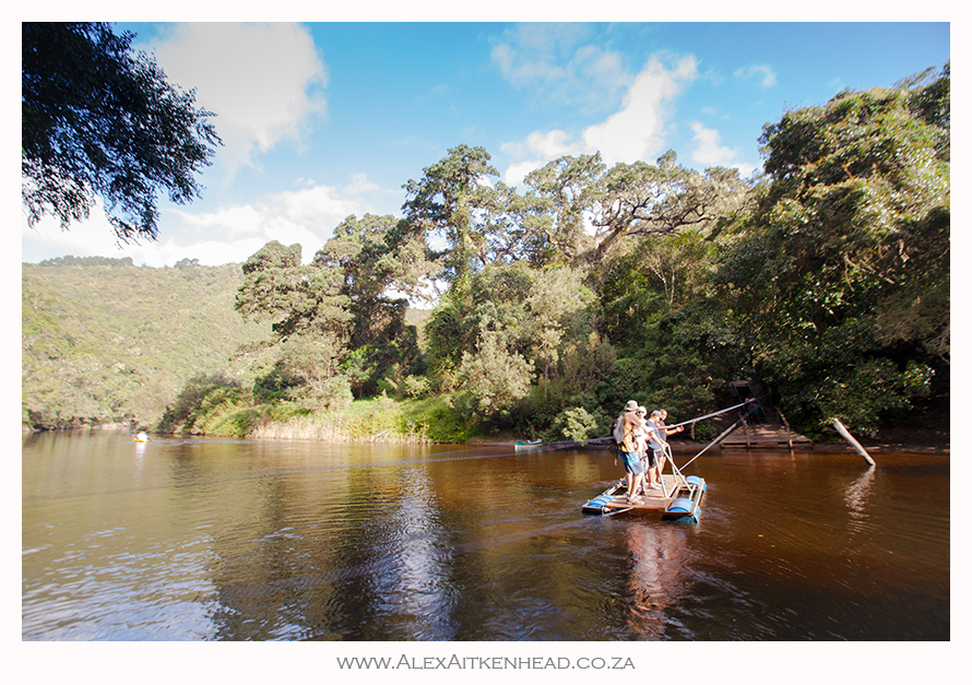
Halfway to our destination we had to cross the lovely Touw river by means of a fun pontoon.  Each to their own here.


A selfie was the order of the day while crossing the river on the pontoon !


A short distance after we crossed the pontoon, we found the Kayak-stop.  This is where the rowers parked their kayaks to continue their journey on foot to the waterfall another 2km further.


The tranquility of the river was the perfect spot for us to take a short break and enjoy the moment.  Our 2 year old son loved the cool water and 'rocks for Africa' to throw...


This well maintained board walk was an absolute pleasure, never been so spoilt for such a long distance on a hike before!


Eventually after 2 hours and 4km later, we reached the waterfall.  


From here we turned around and raced back, daylight time was not on our side as neither of us brought a Petzl with us and both of us ran out of phone battery.  Rather silly, but we did not expect this route to be as nice, and so long.  Key here is to always come prepared I guess.


Feel free to ask questions in the box below, I will be happy to help if I can.  Thanks,

As for the King Fishers... I did not hear or see any???

PS:  all these pics were happily shot from my Sony Xperia waterproof phone that I love, but there are a few beauties squeezed in that my hubby took with his brick ;)

Happy Hiking!

Saturday, March 13, 2010

The Big Tree in the Tsitsikamma forest


Hiking Trail: Big Tree and Ratel Trail
Name of Reserve / Area: Tsitsikamma National Park
Nearest Town: Storms River Village, Plettenberg Bay
Province: Garden Route
Country: South Africa


Duration of hike: 1 - 2 hours depending on how far you wish to walk. The boardwalk to the Big Tree is a 1km circular walk, from there you can continue along the path for up to just over 4km walk to more big trees and fallen giants.


Directions to get there: From Cape Town, take the N2 towards Plettenberg bay. About 60km pass Plettenberg bay, and just after the turn to Storms River Village on your right, is the turn to the left which takes you to the parking area for the Big Tree walk.


Contact Information:
SANparks - Tsitsikamma Indigenous Forest
Phone: +27 (0) 42 281 1557
www.sanparks.org


This is a 800 year old Yellow wood tree, with a height of 36.6m, Trunk length is 18.3m and it takes 8 adults holding hands around the girth.

Best time of year to go: Anytime.


What costs did you incur to do this hike: R8-00 Adults and R4-00 Children
Free entry (if you are a South African Citizen) for Wild Card Holders (www.wildinafrica.com)


How safe is it: Even though we felt very safe walking through the forest, we are always equipped with a mace pray and a shocker.


Visitors Hours: 06h00 - 18h00


Fresh Water: All running water in the river is drinkable. The brown colour of the water is due to tannins and humic acids leached from leaf litter on the forest floor.


Difficulty: Three routes have been laid out and colour coded with red (4.2km), yellow (2.6km) and green (1km) footprints giving a choice of walking distances. All three these walks are relatively easy.


Pets: No pets allowed in the park.


Permits:
Access to the Ratel Nature Walk (after you have entered the park for the Big Tree Trail) can be obtained by means of self-issue permits that are available at the start of the walk. You are requested to carry your permit with you at all times.


How will I rate this hike? We loved the neatly laid out boardwalks. Its always sad to see only 1 or 2 of the 800 year old trees around, but its good to know they are still standing.


I was so excited to see a Knysna Dwarf Chameleon. He survived a crowd of 8 people walking over him.


These chameleons are a favourite for the very poisonous boomslang that frequents the eastern cape region. The boomslang is a very non-aggressive and shy snake, which makes the risk of a bite very low. We happen to run into a female boomslang later on in our travels, I was so excited to finally see one in the wild - wowee :)


Wednesday, January 20, 2010

Waterfall Hiking Trail (aka Day 1 Route and start of the Otter Trail)

Get your walking shoes on, put on enough sunblock, take lots of drinking water and experience nature at its best!


Hiking Trail: Waterfall Trail (Known as Day 1 Route and start of the Otter Trail)
Name of Reserve / Area: Tsitsikamma National Park
Nearest Town: Storms River Village, Plettenberg Bay
Province: Garden Route
Country: South Africa


This route starts (when facing the ocean) to the far right of the Storms River Mouth Resort, just next to the camp grounds. Wow! this was such an amazing walk we had here.

One is often exposed to only one type of environment... Here we had thick dense forest, some board walks and bridges, shrubbery, rock scrambling, flat open fields, bolder hopping along this magnificent coastline and a nice freshwater pond to swim in at the end... definitely a must do when you visit the area.

Duration of hike: 4 hours if you stop as often as we do to have fun and take pictures. Its a 6,4km route to the waterfall and back. Without stopping, it took us about 45 minutes to walk the 3.2km back to base.


Directions to get there: From Cape Town, take the N2 towards Plettenberg Bay. About 60km pass Plettenberg Bay, and just after the Blaauwkrantz River is a turn to the right which takes you to the entrance of the Tsitsikamma National Park by the Storms River Mouth Rest Camp.


Recommended starting times:
Summer: not later than 14h30
Winter: not later than 13h30


Contact Information:
SANparks - Tsitsikamma Section
Phone: +27 (0) 42 281 1607
Reservations: +27 (0) 12 428 9111
www.sanparks.org/parks/tsitsikamma
reservations@sanparks.org


Best time of year to go: Anytime.

The route is marked with little yellow otter paw prints all along the way...


What costs did you incur to do this hike:
Entrance to the Park: Free entry (if you are a South African Citizen) for Wild Card Holders (www.wildinafrica.com)
Accommodation: varies from Camping to Stunning self Catering log cabins of up to R900 per night in season.
Actual hike: Free when in the park.


How safe is it: We felt very safe walking in the park and on this route. Do not go without water as its is a long walk and there is limited shade from the heat of the day.


Fresh Water: Only at the camp. The walk does cross a stream at various points but its not recommened to use as drinking water.


Difficulty: Due to the uneven & slippery terrain, The Waterfall Trail is rated as difficult and is not recommended for unfit hikers.


Pets: No pets allowed in the park.


How will I rate this hike? The route hugs the cliffs all the way to the waterfall. We experienced bolder hopping and rock scrambling, as well as various flat sections all along the route. At the start we were very fortunate to see a Blue Duiker grazing on the beach below us. The pond below the Waterfall provided everyone with a welcome break from the heat of the day. The Tsitsikamma area is experiencing a severe drought during the time we visited the park (and wrote this article), which explains why the waterfall was so small.


The actual (and very popular) Otter Trail starts on this walk and continues past This waterfall for about 45km in total. It takes the hikers an average of 5 days to complete this grueling but very scenic challenge, and is booked out 2 years in advance.

New to reading blogs?

I have heard so many people saying they are new to reading blogs. Here is the 'low down' of what you need to do:

1. The blog is written in date order. Latest posts are at the top and older posts below them. Older posts have a link to them - find the link if you scroll right to the bottom of this screen - see Older Posts.
2. Click on the post header if you wish to make comments below the articles. Comments are most welcome :)
3. I blog our hikes to help other people find nice hiking routes, but also because we love taking pictures on our hikes.
4. On the right column are images of some of the hikes we have done so far. Click on the images to read about those hikes.
5. Subscribe to my newsletter if you wish to get updates of new posts. I will not inundate you with mails - promise.

Thanks for reading my blog and hope you enjoy the read.

There is an old saying...

The more you learn, the more you realize how little you know.