Search This Blog in the above block
~ I dont blog about things to be liked. I blog about things that I like ~ ... so that one day, on my death bed, I will have said and done what I wanted to do, and die peacefully without regrets.
Live your life in such a way that when your feet hit the floor in the morning, Satan shudders & says..' Oh shit....She's awake'

Sunday, September 26, 2010

Wolfberg Cracks - Part 4: Heading to Wolfberg Arch

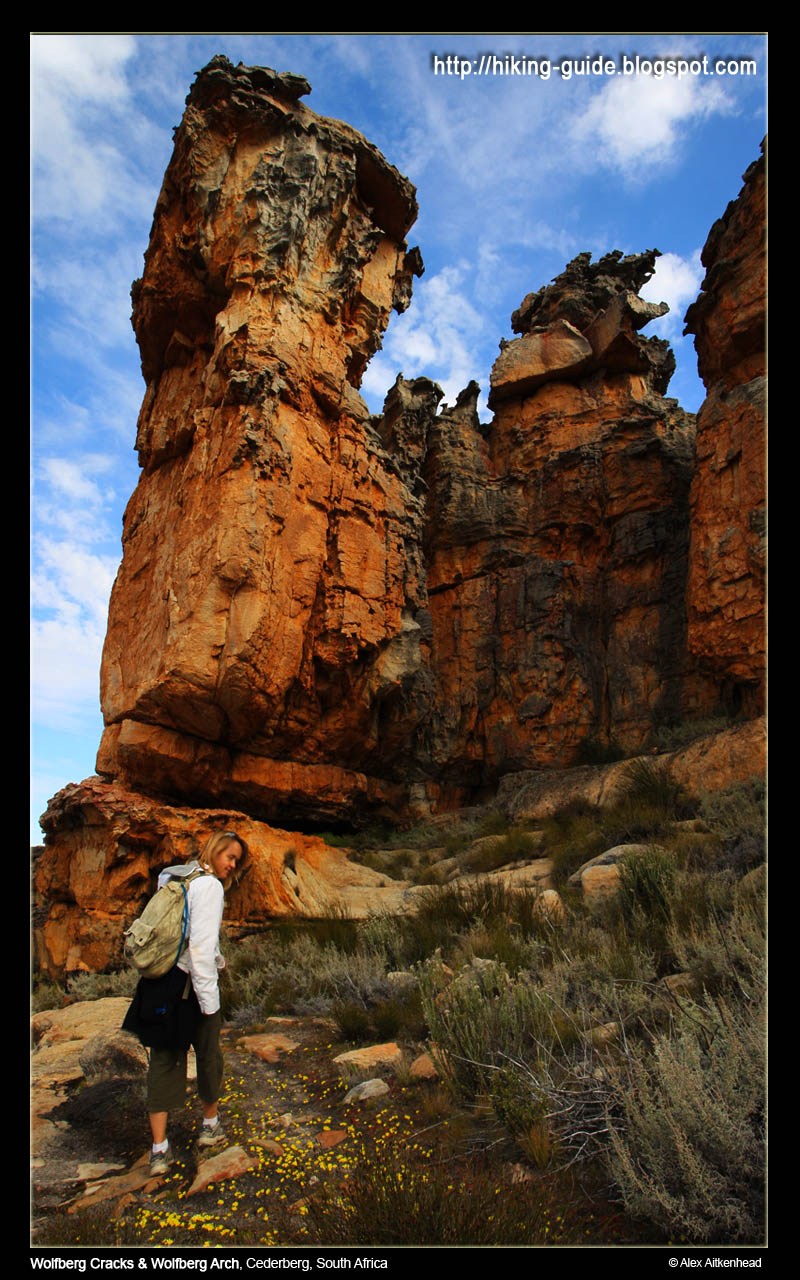
If you come to hike in the Cederberg, be sure to be entertained by the most beautiful rock formations.

The weather was perfect for us (late September), with a crisp breeze blowing the whole day, the hot sun to keep us warm, and the most beautiful blue sky.

All images by Alex Aitkenhead.
Click on images for larger views or go to Alex's blog for desktop sizes.
Immediately as we came out of the cracks, we could see the Wolfberg Arch in far the distance.  This was the last time we saw it, for about another 45min of walking.


To get to this point, (The Sign Wolfberg Arch), we hiked up the mountain, then chose to go through the very scenic Cracks.  After a short coffee break at the top of the cracks, we walked in the direction of the Wolfberg Arch, down towards the end of the small valley that we found ourselves in.  We were told by our virtual guide (Gerrit) that this is the exact point that we have to mark very clearly.  He said the following:

When you get to the end of the valley and see the sign, immediately turn left and go around the rocks. Notice a path going down the mountain again.  Clearly make a marker here for yourself, so that upon your return from the Wolfberg Arch, you will know exactly where to go down.  This will be your down route, also known as the easy way up and down.  He said: "be sure to take the easy way down, because you will need it and there will not be time for you to try and find it when you come back to this point".

So we made our mark.  And then turned towards the sign and the obvious path going towards the Wolfberg Arch.


This route was very easy to follow as all you needed to do was keep your eye on the cairns built by the thousands of hikers who have made this route before us.  Thanks to those who have contributed to making this route such a pleasure to follow!


All that you can hear is the sounds of nature, and sometimes you are reminded about the beauty of silence too. 


It would be sin to not notice these giants molded to perfection by time :)


This must be the first hike I have ever been on, where I can see our destination for almost the entire way.


It felt like it was never getting any closer!


Aaaaahhhh, the end is near...  (eh, well, this end)


Jeay!  We made it. Easy peasy.


Alex taking all sorts of weird pictures, while Im doing what normal people do when they get to their destination: chill and enjoy the view.


He took so many nice pictures, I decided to load them all!  Thanks Al :)


Due to time constraints, we could not stay too long.  30mins was our mark.  Its 15h30 and time to head back to make our way back down the mountain.  We have enough time, but we are scraping it fine.


After walking at a pace, it took us about 1h00 to get back.  We hardly stopped for photo's to catch up on some time and reached the cracks at 16h00.  Both of us were exhausted but pushed on to commit to our final stage of our fabulous journey.


Read on about how we made it down the mountain ...

Wolfberg Cracks - Part 5: The Easy Route Down


Having come from the Wolfberg Arch, we wanted to be back down by at least 18h00. By this time I was exhausted and decided to take a slow pace down.

We returned to the Wolfberg Arch sign, then we went to look for our marker that we planted before we left, and we were comfortable to know we were going down the right way.


The path is very clear, so it was not difficult to find at all.  No need for describing where to go, again the cairns were a blessing.


At this point I decided to take short 5 min break, to regain some strength to head forward.  Its almost more difficult to stop, because then your legs become lazy from being so tired.  My feet were hurting more than anything by now.


The picture below is showing the last stretch of the easy down-route (6) of the crack. I only inserted it to give the readers an understanding of this is where your path splits when you go up (5), and again the path that you come back to when you come down from the other side.  (The picture is of me going up, so dont let it confuse you if you wish to use this article as a guide.)


How do you climb a mountain?  1 step at a time.  I had to remind myself:  "its the same for getting back down - 1 step at a time".


We reached the car at 18h00.


And were spoilt for choice again with the most beautiful of beautiful sunsets over the Cederberg!


The memories of this hike will surely last forever.  Alex is the most wonderful hiking partner, and he pushes me all the way.  I enjoy being challenged and would not want it any other way either.

Thanks again to Gerrit at Oasis for being our virtual guide all the way!

We really would love to come back and do this route again some day in the near future.  We will be bringing our mountain bikes with us and stay for longer.  Maybe next September again?!

Monday, September 13, 2010

Free access to South African National Parks 13 - 17 Sept 2010

Media Release: Free access to National Parks starts this week

From Monday, 13 September until Friday, 17 September, the country’s body charged with the management of national parks, South African National Parks (SANParks) will allow locals with valid identity documents an opportunity to spend a day at a national park of their choice free of charge.

The week-long campaign giving free access to the national parks will be applicable to all the national parks managed by SANParks, with the exception of Boulders in Table Mountain National Park, Tankwa and Namaqua National Parks.

According to SANParks General Manager: Media Relations, Reynold Thakhuli, the objective of the week is to cultivate a culture of pride in all South Africans in their relationship with the country’s natural, cultural and historical heritage, under the established theme “Know Your National Parks”.

The idea of a national parks focus week was conceived in 2006, after a realisation that a vast majority of South Africans were not accessing the national parks. “SANParks then embarked upon this campaign to encourage all South Africans, especially those from the communities around the parks, to share in what SANParks envisions to be “the pride and joy of all South Africans and the world”.

The feature element of this campaign is the free access granted to all South African day visitors carrying their official Identity Documents. Young persons under the age of 16 will be allowed free access without the requirement of proof of identity. It must be noted that the free access to the parks will not include any commercial activities in the park such as guided safaris in vehicles or guided walks, etc.

“Environmental education and protection is the responsibility of everyone, not just a privileged few. If we are to create a sense of ownership of the natural heritage of South Africa in all South Africans, then all South Africans must be able to have access to such,” said Thakhuli.

“We especially want our young people to take advantage of this opportunity because this heritage will be under their protection in the near future,” added Thakhuli.

“The annual SA National Parks Week has been made possible with support from First National Bank since inception. “In recent years, awareness of environmental issues and the impact we have on our environment has increased greatly. At FNB we recognise the immediate and potential threats posed by global warming and other environmental issues, and have taken steps to minimise our impact on our surroundings, said FNB Public Sector Banking CEO National Government,” Yvonne Zwane.

“FNB has embarked on environmentally friendly initiatives such as: energy saving that reduces the load on the Eskom grid, water conservation processes, paper saving initiatives and encouraging the use of recycled paper. This precipitates environmental impact reduction for a sustainable future through energy efficiency, water efficiency, waste re-cycling and indigenous gardens. Furthermore FNB has completed initiatives such as the development of the environmentally friendly Fairlands Building moving South Africa a step closer towards an environmentally friendly society,” concluded Zwane.

SANParks encourages all South Africans and especially educators and school groups to diarise these dates and plan a visit to a national park nearby.

For more information and activity list visit: http://www.sanparks.org/events/parks_week/2006/

Visit us on: www.sanparks.org
Joining our discussion forum: http://www.sanparks.org/forums/
Follow us on Twitter: http://twitter.com/SANParks
Become a fan on Facebook: http://www.facebook.com/pages/South-African-National-Parks/20031840634
Issued by:
SANParks Corporate Communications

Media Enquiries:
Reynold “Rey” Thakhuli – GM: PR, Media & Stakeholder Relations, tel: (012) 426 5203, cell: 073 373 4999, e-mail: reyt@sanparks.org

Thursday, July 1, 2010

Hiking Trails in the Cederberg


This hike comes highly recommended if you wish to take the family on an outing into the Cederberg this winter. Make sure you book accommodation in advance - as the long weekend falling over the 9th of August (in South Africa) will become booked out in no time.

Sevilla Rock Art Hiking Trail


Other hikes to consider is also the 'Wolfberg Cracks' and 'Die Tronk to Die Hel'

For flowers (end July - Sept), your best option will be Postberg in the West Coast Nature Reserve near Langebaan.

Enjoy!

Tuesday, June 22, 2010

Accommodation for the Fish River Canyon

We have booked our roadtrip to the Richtersveld and Kgalagadi , but I have a problem finding accommodation for the Fish river canyon.

All we want is a reasonably priced chalet to put our heads down en route from the Richtersveld to Kgalagadi. We are even happy to camp, but would like the chalet option - since we are spending only 1 night in a place.

The reason for my asking this too is that when we went to Addo, we had no idea there were SO MANY Bed and Breakfast spots just outside the park... as we had to plan our whole holiday around the few days they had spare for us inside the park... had we only known.

any suggestions (other than the Canon spots and the Ais-Ais) will be great, thank you.

Thursday, June 17, 2010

My Cape Town "I just want to be like you" video by I Scream and Chocolote Stix

There is nothing like a little more genius coming from our locals.  What a fun video about how it really is here right now.


"My Cape Town" by I Scream and the Chocolate Stix - Music Video directed by Porteus Xandou. The Emergency Hours. from Mannequin Pictures on Vimeo.

Monday, June 14, 2010

Fatality in Skeleton Gorge onTable Mountain


I think this is where it happened and would like to remind all visitors to Table Mountain to please be very careful.  This mountain has 4 seasons in 1 day.  The rain makes is extremely vulnerable for rockfalls and creates very slippery surfaces.  My sincere condolences to the American family. 

IOL.com News Article of this sad incident.


Sunday, June 6, 2010

Hiking Smuts Track on Table Mountain

Hiking Smuts Track was not a another walk in the park.  Again, another breathtaking walk - famously known to have been the route of General Jan Smuts which he walked up to the age of his mid eighties.


I had my heart rate monitor on, and burnt 1680 calories from start to end.  Had we not done the cable way down, Im sure I could have added another 400 calories to this figure.

The route starts at the foot of the mountain by Kirstenbosch Botanical Garden.  It cost us R35 each to get through the gates and onto the route, which is via Skeleton Gorge.

Follow the Skeleton Gorge signs inside the Botanical gardens.

Kirstenbosch Botanical gardens is also a very popular venue for Concerts in the Park.

The path going up varies between wooden foot steps and well placed rocks.

This route is a difficult and potentially dangerous climb, particularly in wet weather.


A good 30 minute walk from the TOP Entrance gate in Kirstenbosch, will take you to cross over the Contour Path and a small sign indicating the start of Smuts Track (there is no confusion as to which way it is, but only up)

The path zig-zags its way up the steep stone steps into the gorge. During winter this is the main flow down for the Liesbeeck river. I particularly love this section of this route the most. Its not often that one can see so much green moss covering the rocks in such a condensed area.


About two thirds of the way up Skelleton gorge, we reached a few wooden ladders (and gladly no chains as the sign indicates).  These wooden ladders are a real welcome!  Usually by now we've had our second break, but today was one of my stronger days for climbing and we went up in one go all the way to the top.

Looking at these pictures, Im very sad to say that my new Blackberry 9700 Bold takes very poor pictures compared to my Nokia N82.  Dont get me wrong, I just love the Blackberry for what it has to offer for business etc, but for taking photo's it gets a thumbs down. Had I not dropped my Nokia so many times (on my hikes!) and it was still working, I would have used it hands down as my main source for taking my pictures.

Once we emmerged from the Gorge and its dense forest below, the view of False Bay and the Helderberg is clearly seen.  During a cold winters day, the rays of the sun is also a warm welcome.

From here, we walked another 20min up the steep incline before we reached our next crossroad.

At the first crossroad once we reached the top, we turned right to follow the path hugging the side of the mountain overlooking Kirstenbosch and surrounds.

The good news is we reached to top of Skeleton Gorge, the bad news was... the 'mountain' ahead of us.

Its very disheartening if you think you have reached the top, when you see another monster hill in front of you.

Our GPS indicated that we were on about 800m from here, and we had another 280m to go before we reached our peak... MacClears Beacon.

The climb to the top of the beacon was actually a beautiful walk and fairly easy to walk in about 1 hour from the top of Skeleton Gorge.


At the top of the fabulous walk we were again blessed with a near 360 degree view of the Cape!  This is for sure a must do walk if you have not done it.


MacClears beacon marks the highest point on Table Mountain of 1080m.  We started walking at an altitude of 50m, so a 1km climb over about 4.5km is not too bad for one to consider it a good walk for the day.

We found a comfy spot on the rocks at MacClears Beacon to have our halfway mark lunch break.  Looking down onto our route of last week - Devils Peak.  Im still keen to find a way from Devils Peak to MacClears... not sure if there is one?  Have seen a few faint paths on Google Earth, but Im going to have to set out on a mission to find this one.

Due to our respect for this majestic mountain, we are very careful to not just go wandering off onto some route into the unknown...


After a short break, we ventured on - heading directly for the cable way.  This path follows a almost flat path all along the face of Table Mountain.  I just love it here, and would recommend it to anyone to come and see the views this fairly easy and flat section has to offer.

The path literally hugs the cliff face for us to enjoy looking down onto Lions Head and the city of Cape Town almost all the way back to the Cable Station.

Thissection is us looking at Platteklip Gorge from an angle we are not too familiar with.  Platteklip Gorge is the easier route to walk up to the top of Table Mountain if you do not wish to take the cable way.  Be sure to remember that Plattes (as known by the locals) has no mercy for the unfit either. 

The Upper Cable Station is very well equipped - the walkways are also made for easy access for disabled persons - and there is a rather pricey restaurant / coffee shop at the top.
 Ha ha, this is Alex - DONE!!!  I dont often find him chillaxing like this after a walk...  blaming it on a weak stomach - I told him to ease off on the italian salami he had the day before :)

We remembered to take the Wild Cards, which eased off on the price tag of taking the Cable Car down.

Normal price is about R85pp one way, but it cost us R68pp as South African Citizens we had the Wild Cards which helped us get it at a more discounted rate.

You can also buy tickets online if you dont feel like standing in the queue. Note: This queue for the cable way coming up is often over an hour long.

This is a snap that I captured as the cable car started moving down - with the lower Cable Station in sight.


Here is the view from the cable car, looking at the point of mountain we had just come from... I just love staring at the mountain after a walk... trying to see if I can recognise our path we had just done.

Another favourite thing of mine to do, is to draw our route of the day off Google Earth map.

Before I got the Garmin eTrex Legend, I used to do this type of picture manually.  Now the GPS does it for me automatically.  Love it!


Costs of route:
R35pp entrance fee to Kirstenbosch Botanical Gardens
R68pp down the cable way with a Wild Card.

Distance: 8.5km
Altitude: start 50m to 1080m at MacClears Beacon
Calories: 1680
Time: 4 hours


What a walk!  We did this walk just over a year ago, but forgot to take pictures (it was raining and we had a white-out on the day - loved that toooooo!), but at that time we were focusing on staying on the track. Great walk, great workout and good all round fun as part of living the life that our environment has to offer us.

New to reading blogs?

I have heard so many people saying they are new to reading blogs. Here is the 'low down' of what you need to do:

1. The blog is written in date order. Latest posts are at the top and older posts below them. Older posts have a link to them - find the link if you scroll right to the bottom of this screen - see Older Posts.
2. Click on the post header if you wish to make comments below the articles. Comments are most welcome :)
3. I blog our hikes to help other people find nice hiking routes, but also because we love taking pictures on our hikes.
4. On the right column are images of some of the hikes we have done so far. Click on the images to read about those hikes.
5. Subscribe to my newsletter if you wish to get updates of new posts. I will not inundate you with mails - promise.

Thanks for reading my blog and hope you enjoy the read.

There is an old saying...

The more you learn, the more you realize how little you know.