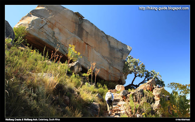
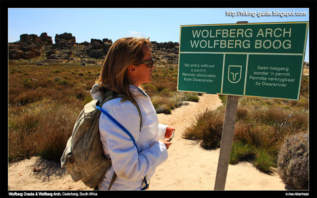
Hiking Trail: Wolfberg Cracks and Wolfberg Arch
Name of Reserve / Area: Private Property, Cederberg,
Nearest Town/s: Clanwilliam via N7, or Ceres via N1
Province: Western Cape
Country: South Africa
Duration of hike: 8 hours
Directions to get there: It took us 3 hours from Cape Town, but we also were stuck in the peak hour traffic at 16h00 for an hour, so it took us 4 long hours to get there.
From Cape Town CBD, take the N1 towards Paarl. Take the turnoff towards Wellington, and pass through it and follow the R44. Pass the Voelvlei Dam on your right and continue until the road makes a 3way junction. Turn right at the junction towards Ceres (and not Tulbach). Follow the road to Ceres. Once you get into the small town of Ceres, turn left at the second set of traffic lights. Pass through Prince Alfred's Hamlet.
As soon as you have driven through PA Hamlet, you will head up onto the Gydo Pass, which then takes you to an even smaller town called Op Die Berg (in an area also known as Die Koue Bokkeveld). Continue on the R303 and soon just outside Oppi Berg, you need to turn right at the Cederberg Sign
A 17km tarred road will take you onto a gravel road. From here you need to keep left and follow the Oasis signs for 48km to your over night destination called Oasis.
The following morning we had a scrumptious breakfast, bacon, eggs, toast and a good cuppa coffee to get us going. This farm kitchen is filled with character and definitely worth a visit.
Gerrit was ready to personally draw up the map of our planned route for the day. This was 2 A4 pages of pure mapping on both sides. We held on to this map like never before. And oh boy, did this map help us enjoy our journey just that much more. Thanks Gerrit!
With your back to Oasis, you follow the road to the right for about 6.5km and turn left at the Clan William sign.
...3km further is where you pass the sign for Stadsaal Caves and Rock Art.
Drive for another 3km where the road forkes left to Krom Rivier. Dont turn left here, but take the right more obvious main road and drive for 5km to the Sanddrif Wine Farm. This is where we stocked up on necessities (like Cederburg Cabernet) and our permits for the hike.
After leaving Sanddrif main house, turn left towards another Sanddrif sign. The road drives down into the valley through a few cottages and soon you will cross a low water bridge. After the bridge take a sharp right. The road splits into 3. Take the left fork, drive pass more cottages and what seemed like a stunning and very popular camping ground. The road forkes again, take the left fork upwards until you reach the gate. Enter in your code and drive through to the furthest end where you can park your car and start the walk.
Contact Information:
We stayed at the Oasis Bed and Breakfast.
GPS CORDINATE
23. 33. 20. 21 S
19. 21. 55. 31 E
Tel: +27 27 482 2819
cederberg@telkomsa.net
The owners were extremely friendly and welcoming. Once you get there, you feel a very welcome vibe. The visitors seem like regulars, and the place was packed to the brim with tents and the rooms were all fully booked.
Our room did not have an on-suite shower, but we were lucky to have the loo next door to it and a small area on the balcony to make our fire to cook our food on.
Cost was R120pppd, and breakfast was an added R40pp, but comes highly recommended before a journey like the one we were about to tackle.
Best time of year to go: .
April (its coming to the end of summer) and September (just after winter, and flowers everywhere)
What costs did you incur to do this hike:
Accomodation: R120pppd
Breakfast: R40pp
Permit for Cracks: R25pp
Permit for Arch: R25pp
How safe is it: There is no crime here.
Fresh Water: None. Take at least 3 liters per person if you are going to the Wolfberg Arch.
Difficulty: Very easy climb to the top, but its a long hike. Tricky to know where exactly to go, but with good guidance from our host at Oasis (Gerrit), we headed for the hills with confidence.
It took us about 1h30 to get to the top of the cracks.
Then another 1h30min inside the cracks,
30min coffee break
and then an 1h30min to walk to the Arch.
30min at the Arch,
1h30min to walk back,
and 1h30min to get back down.
Total walking time of about 8 hours...
Pets: No pets allowed, environment is very harsh.
How will I rate this hike? Best hike Ive done so far in my life. Loved it.
The rest of this hike is documented under the Wolfberg Cracks link. I hope you enjoy reading this hike as much as we enjoyed doing it. Or just scroll down for Parts 2,3,4 & 5.
We can not wait to go back here again, and hopefully take a group of people with us next time.
Search This Blog in the above block
~ I dont blog about things to be liked. I blog about things that I like ~
... so that one day, on my death bed, I will have said and done what I wanted to do, and die peacefully without regrets.
Live your life in such a way that when your feet hit the floor in the morning, Satan shudders & says..' Oh shit....She's awake'
Sunday, September 26, 2010
Wolfberg Cracks - Part 2: Finding the Crack
Panorama of Sanddrif Valley.
(Click on images for enlargement
all images by Alex Aitkenhead)
To get to this part of the hike, we drove for 4 hours from Cape Town, and spent the night at Oasis Bed and Breakfast. Then we drove another 22km to get our permits at Sanddrif Wine Farm, and our final 2km to get to the parking area and the start of this route.
I had been waiting for 2 years to do this route. There was always something that stopped me from doing it. Alex and I were both very excited to finally get here and start the trek up this gauntlet.
This part of the route is fairly simple: Follow the path to the top.
It was not long before our car became a small speck in the car park below.
After walking for 45 minutes, you will reach this massive square rock. This marks the halfway spot in your up route in terms of time.
The tricky part of the route starts here. I have marked the rocks in the picture below to help you should you wish to follow this route yourself.
1,2,3 are bolders that have rolled down and blocked the path up. This is where you need to find your way around the right of boulder 3 and get to the back of it and aim in the direction of point 4 behind it.
(Note: if you pass the left of boulder no.1, you can also climb up the easy route to the top (follow the sign). This is not recommended, as you will be missing out on the most special part of this route).
4. Here you are faced with a 2.5m (90 degree) climb onto the ledge leading to point 5. But first get yourself to point 4.
Once you have reached point 4. A short scramble to the top will take you onto a easy ledge.
Follow the ledge to the end, turn left at the end. Be careful as there is one section where the ledge is not wider than an A4 size paper. It gets better immediately after this point.
A short scramble will take you to a massive arch in front of you. Once you reach the arch, scramble between the rocks marked 1 & 2 into a beautiful rock-filled amphitheater.
In the picture below, the amphitheater is show to be about 20m in width. Scramble over the rocks, directly across and opposite the arch. Do not take the more obvious (but not easy) route to your right (more or less where the people are standing in the picture). Rather walk across in the direction of where this photo was taken from. Im sorry to not have taken a picture of this, but for now this is the best that I can do here.
You will be walking towards a massive rock cave, seen in the image below.
Above pic sourced from lastfrog.co.za
Enter this cave on its left side. Its a tight squeeze for 6m of darkness. But you are able to see the light on the other end, the moment you enter the cave. Be careful, and best to switch on your petzl lamp on this tiny part of the route.
The next section of this route took us into the most beautiful rock formation hidden deep into this mountain.
Wolfberg Cracks - Part 3: Adventures inside the Crack
The fun began here. Entering this passage was the start of a 200m adventure into the mountain.
This is a dark narrow passage of about 6m long.
The other side of the passage brings you to a sandy spot where the party can re-group before the next adventure. Make sure you bring your Fisheye lense- if you have one! (We forgot ours at home, so its another reason for us to just have to come back here again) - jeay!
venture around as much as possible and enjoy the moment for what it has to offer. stop somewhere here and have lunch, and give yourself time to really look around.
to get to the next level, keep to the right of the crack...
crawl under this large rock to the next section of the passage...
The arches and rock formations are like some of my friends would say: "to die for darlin'!"
The chief happy snapper taking a break ... (he was fired from all and any navigational duties, but he is still allowed to take snaps) ~ LOL
Soon the crack is split into 2. This is where you must take the left passage at this section as seen in the pic below.
Alex, the love of my life, doing what he loves doing :)
The passage is very long and becomes narrower as you walk into it.
Once you reach what seems to be a dead end, don't despair. But its a tricky 2m scramble to the top of this rock. This is a link to an image of an easy way to get up.
Once you have reached the top of this rock, after 5m you will notice your last obstacle before you exit this crack. Its a trapped rock. You need to lie on your back, and go head first into the hole. Its the only way you will be able to get your body out on the other side. See the graphic of the image below on how to do this.
This lady is about to get through this trapped rock. Its very easy and thousands before you have done it already. So don't be afraid. Leave your city fears behind you and Just Do It!
Within 2 minutes of walking you reach the top of this crack.
In the image below I looked back into the crack. All you can see from here is the thin and narrow split in the mountain ...
Find a spot to enjoy the view and have a quick coffee break before you head off to your next adventure.
From here you have 2 choices:
1. Go back down. (We came from the crack behind me to my right. The way down is the bushy patch on my left.) 1h30min to get back down.
2. Follow the clearly marked path to the Wolfberg Arch. Please see Wolfberg Cracks: Part 4. 3 hours needed for this section to get back here.
Wolfberg Cracks - Part 4: Heading to Wolfberg Arch
If you come to hike in the Cederberg, be sure to be entertained by the most beautiful rock formations.
The weather was perfect for us (late September), with a crisp breeze blowing the whole day, the hot sun to keep us warm, and the most beautiful blue sky.
All images by Alex Aitkenhead.
Click on images for larger views or go to Alex's blog for desktop sizes.
Immediately as we came out of the cracks, we could see the Wolfberg Arch in far the distance. This was the last time we saw it, for about another 45min of walking.
To get to this point, (The Sign Wolfberg Arch), we hiked up the mountain, then chose to go through the very scenic Cracks. After a short coffee break at the top of the cracks, we walked in the direction of the Wolfberg Arch, down towards the end of the small valley that we found ourselves in. We were told by our virtual guide (Gerrit) that this is the exact point that we have to mark very clearly. He said the following:
When you get to the end of the valley and see the sign, immediately turn left and go around the rocks. Notice a path going down the mountain again. Clearly make a marker here for yourself, so that upon your return from the Wolfberg Arch, you will know exactly where to go down. This will be your down route, also known as the easy way up and down. He said: "be sure to take the easy way down, because you will need it and there will not be time for you to try and find it when you come back to this point".
So we made our mark. And then turned towards the sign and the obvious path going towards the Wolfberg Arch.
This route was very easy to follow as all you needed to do was keep your eye on the cairns built by the thousands of hikers who have made this route before us. Thanks to those who have contributed to making this route such a pleasure to follow!
It would be sin to not notice these giants molded to perfection by time :)
This must be the first hike I have ever been on, where I can see our destination for almost the entire way.
It felt like it was never getting any closer!
Aaaaahhhh, the end is near... (eh, well, this end)
Jeay! We made it. Easy peasy.
Alex taking all sorts of weird pictures, while Im doing what normal people do when they get to their destination: chill and enjoy the view.
He took so many nice pictures, I decided to load them all! Thanks Al :)
Due to time constraints, we could not stay too long. 30mins was our mark. Its 15h30 and time to head back to make our way back down the mountain. We have enough time, but we are scraping it fine.
After walking at a pace, it took us about 1h00 to get back. We hardly stopped for photo's to catch up on some time and reached the cracks at 16h00. Both of us were exhausted but pushed on to commit to our final stage of our fabulous journey.
Read on about how we made it down the mountain ...
The weather was perfect for us (late September), with a crisp breeze blowing the whole day, the hot sun to keep us warm, and the most beautiful blue sky.
All images by Alex Aitkenhead.
Click on images for larger views or go to Alex's blog for desktop sizes.
Immediately as we came out of the cracks, we could see the Wolfberg Arch in far the distance. This was the last time we saw it, for about another 45min of walking.
To get to this point, (The Sign Wolfberg Arch), we hiked up the mountain, then chose to go through the very scenic Cracks. After a short coffee break at the top of the cracks, we walked in the direction of the Wolfberg Arch, down towards the end of the small valley that we found ourselves in. We were told by our virtual guide (Gerrit) that this is the exact point that we have to mark very clearly. He said the following:
When you get to the end of the valley and see the sign, immediately turn left and go around the rocks. Notice a path going down the mountain again. Clearly make a marker here for yourself, so that upon your return from the Wolfberg Arch, you will know exactly where to go down. This will be your down route, also known as the easy way up and down. He said: "be sure to take the easy way down, because you will need it and there will not be time for you to try and find it when you come back to this point".
So we made our mark. And then turned towards the sign and the obvious path going towards the Wolfberg Arch.
This route was very easy to follow as all you needed to do was keep your eye on the cairns built by the thousands of hikers who have made this route before us. Thanks to those who have contributed to making this route such a pleasure to follow!
All that you can hear is the sounds of nature, and sometimes you are reminded about the beauty of silence too.
It would be sin to not notice these giants molded to perfection by time :)
This must be the first hike I have ever been on, where I can see our destination for almost the entire way.
It felt like it was never getting any closer!
Aaaaahhhh, the end is near... (eh, well, this end)
Jeay! We made it. Easy peasy.
Alex taking all sorts of weird pictures, while Im doing what normal people do when they get to their destination: chill and enjoy the view.
He took so many nice pictures, I decided to load them all! Thanks Al :)
Due to time constraints, we could not stay too long. 30mins was our mark. Its 15h30 and time to head back to make our way back down the mountain. We have enough time, but we are scraping it fine.
After walking at a pace, it took us about 1h00 to get back. We hardly stopped for photo's to catch up on some time and reached the cracks at 16h00. Both of us were exhausted but pushed on to commit to our final stage of our fabulous journey.
Read on about how we made it down the mountain ...
Subscribe to:
Posts (Atom)
New to reading blogs?
I have heard so many people saying they are new to reading blogs. Here is the 'low down' of what you need to do:
1. The blog is written in date order. Latest posts are at the top and older posts below them. Older posts have a link to them - find the link if you scroll right to the bottom of this screen - see Older Posts.
2. Click on the post header if you wish to make comments below the articles. Comments are most welcome :)
3. I blog our hikes to help other people find nice hiking routes, but also because we love taking pictures on our hikes.
4. On the right column are images of some of the hikes we have done so far. Click on the images to read about those hikes.
5. Subscribe to my newsletter if you wish to get updates of new posts. I will not inundate you with mails - promise.
Thanks for reading my blog and hope you enjoy the read.
There is an old saying...
The more you learn, the more you realize how little you know.